Ugh, I am super frustrated that with working, no hiking schedule is being set, i work most weekends and am so tired after I don't feel like moving, this needs to change, I miss hiking, and have SO many hikes i want to do, so here are a few that I have planned so far!!
Crouching lion, it looks to be totally gorgeous!
Ma'akua Gulch, I don't know why i like to do closed hikes, maybe its just the thrill of doing it! but it looks gorgeous
Mount Olympus, which me and Matt may try to do Tuesday
Stairway to heaven, which we plan to do when his brother comes in January
Maunawili Falls, because I love waterfall :)
Wai'oma'o Falls and the hiking around it, there are three waterfalls around there that I would love to see!
I need to get this figured out, hell maybe even quit my job :) HAHA
Sunday, December 26, 2010
Saturday, December 4, 2010
Wa'ahila Ridge Trail to Kolowalu Trail - December 4th, 2010
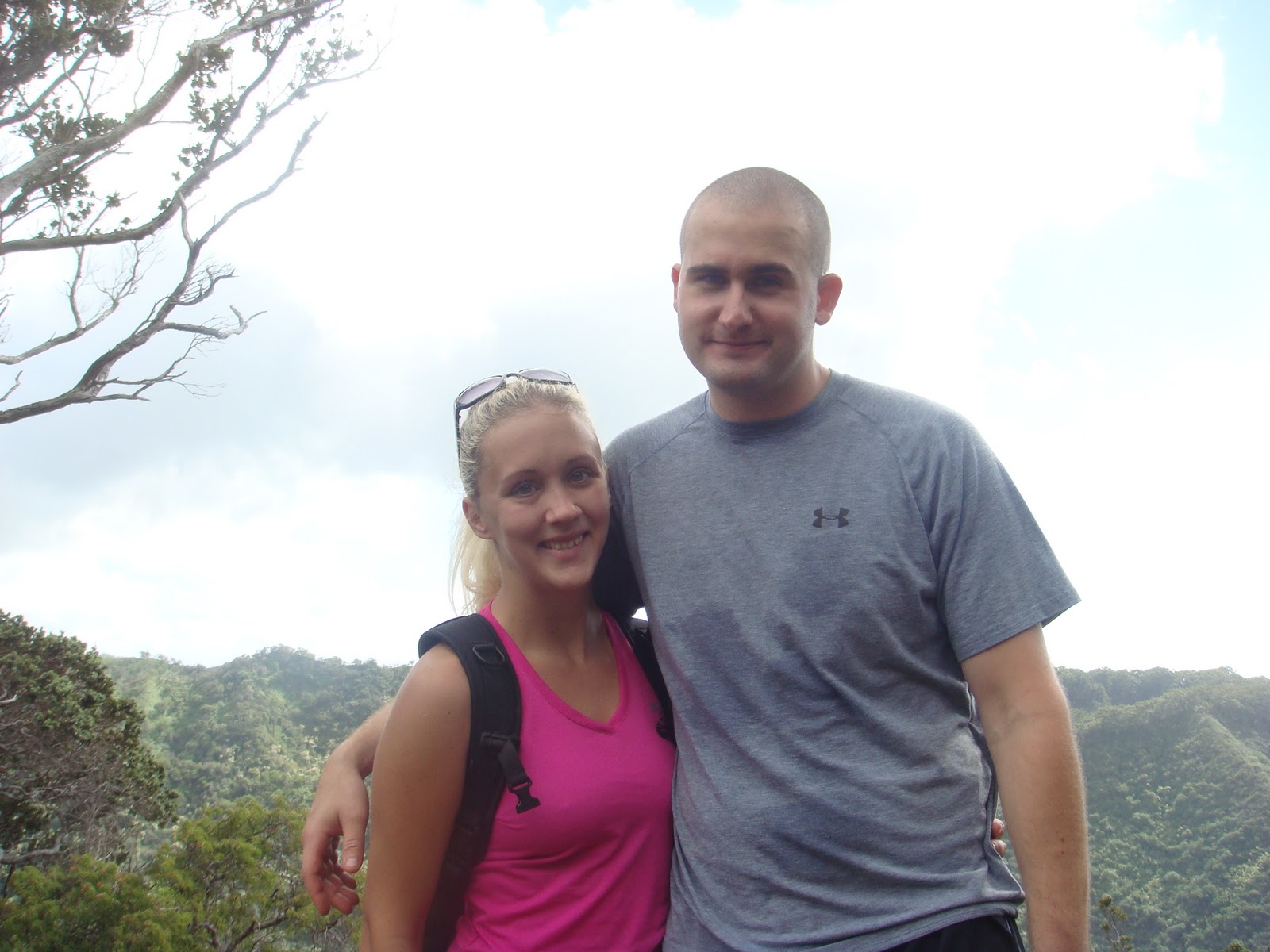
 |
| Matthew and I on the Kolowalu side of the trail |
 |
| These roots in the beginning of the Wa'ahila trail are slippery! |
We started the trail at about 9:45 a.m., with Matt already doing the Wa'ahila Ridge Trail twice and me doing it once, we got through the 1.2 miles in about 45 minutes, which I don't know seemed to be pretty quick, with the rocky climbs up and down, and not to mention the insane winds that were going on AGAIN today, did I mention we had a dog with us too? He was such a cutie, he trucked along pretty well, way better than Matthew and I thought he would, we only had to stop a few times to give the little guy water, he did beg a few times to be carried, which since he was only 5 months old wasn't to big of a deal for Cole. The Wa'ahila Ridge Trail is fairly simple I'd rate it as being easy to moderate, and the only reason I would say moderate is because of the rock climbs which aren't crazy but they do make for difficulties especially if you have short legs, also the slippery roots, since it's so densely crowded with trees sunlight rarely gets to some parts, and rain most definitely gets to all parts! Which means those roots are SLIPPERY! I bit the dust once, my feet just totally flew out but I managed to catch myself, Matthew bit the dust 2 times, but also both times managed to catch himself, Cole I'm pretty sure fell once also.
 |
| Pretty rainbow from the first time we did the hike! |
So, as I said after 45 minutes we made it to the junction of the Kolowalu Trail,, when we went on this hike back in October we started down this trail for a few minutes and stopped at a open grassy area, and then turned back to head towards the car, but this time we hiked it all the way down to the trail head, with an elevation climb up and down of 1100 feet each way, it made certain parts rather tricky, especially when trees are down, and rocks are slippery! That's why they rate this trail as intermediate to strenuous, and this was no joke, it was steep going down and steep going up, taking us 51 minutes to go down, and 53 minutes to go up, I was impressed with our time, since I most definitely had to stop more than once to catch my breath and make my heart stop feeling like it was going to explode!!
 |
| These awesome roots made things better and harder at times! |
 |
| It's true, I love these trees! |
Elevation: -Wa'ahila Ridge Trail- 500 fee -Kolowalu Trail- 1100 feet
Distance: -Wa'ahila Ridge Trail- 2.4 in and out -Kolowalu Trail- 1 mile in and out
 |
| That'd be me and Rocky (the cutie) in the backround! |
Difficulty: -Wa'ahila Ridge Trail- Easy to Moderate -Kolowalu Trail- Intermediate
Directions from when you get into Honolulu!!
Thursday, December 2, 2010
Makapu'u Lighthouse - December 1st, 2010
 |
| Jenna and I |
 |
| Turtle and Rabbit Island |
At 10:30 A.M. we started our little 1 mile hike to the top, stopping to take pictures at all the lookouts along the way, the views were gorgeous!! The wind on the other hand was something to be desired, I would say there had to be 25+ MPH winds! The paved trail to the top was nice to say the least, it made it a really easy hike, almost to easy.
 |
| Makapu'u Lighthouse |
The views of the lighthouse were also gorgeous, there were a few different areas to get some really awesome pictures of the lighthouse from all directions, also views of Rabbit and Turtle island, the Sea Life Park, and KoKo Head, so once we made it to the top, we decided why not go up the mountain on the side, where the winds showed their ugly face again! To the point where if you didn't take a stance and lower your center of gravity you might just get taken off the mountain! It was worth it though, we had a great time, and unfortunately we didn't wear any sunscreen and got pretty fried, not to sure what we were thinking!

Difficulty: Easy
Distance: 2.0 Miles
Elevation: 550 Ft.
Map and Directions
Monday, November 29, 2010
Sacred Falls - November 29th, 2010
 |
| Amanda(lower left)-Tara(upper left)-Me-Michelle |
 |
| Me and Matthew the first time I did the hike |
"Sacred Falls State Park has been closed to the public since a May 1999 landslide tragedy. Even before that incident occurred, the park was considered dangerous, because the footing on the park's trails can be very slippery, and because deaths have occurred on the waterfall trail when flash floods from rain storms in the mountains swept hikers down the canyon.
Eight people were killed and fifty others were injured on Mother's Day 1999 when boulders and rocks collapsed into the narrow valley where Sacred Falls is located. The park has been closed since that incident. The families of the victims received a $8.56 million settlement after a judge declared that ten signs at the start of the 2.2 mile trail leading to the waterfall warning of possible landslides were inadequate. "
 |
| Gorgeous views of the Ko'olau mountain range! |
It is located about one mile south of Hau'ula Town, on Kamehameha Highway. The park was named after an 80 foot waterfall that lies at the end of a narrow canyon. The hike to the waterfalls is two miles one way, and it can be dangerous. Hikers have died when flash floods swept them down the canyon.
It's true what they warn of this hike, it is very muddy, slippery, and there are plenty of narrow walk ways, leading to what I like to call a "game over" drop off along the side! There is also no lack of water in the area! Michelle and Amanda just decided to give up and walk in the water instead of trying to brave the extremely slippery rocks, not that walking in the water would hurt anything, I am just a priss about most things and prefer to NOT get wet! Not to mention the nasty snails we saw along the way! I let out two extremely girly screams!
 |
| Sacred Falls |
Ok, on to how our day went! I woke up this morning at 4:30 a.m. to get my Matthew off to work and make his breakfast and lunch, sat around and watched some TV for a few hours, got ready and headed to pick Michelle up at 7:30, I absolutely LOVE PT (physical training) hour here on base, with the 10 MPH speed limit, and all of the LOVELY stop lights in Wahiawa, that I managed to get stopped by all! Well, I finally got to Michelle 30 minutes later! We then headed to the falls, we pull up around 8:45 a.m. and wait for Amanda and Tara who were heading from Kaneohe Bay. They then arrived a few minutes later, in the meantime, 3 COP cars drive by, and 2 city workers actually head into the sacred falls park! This is making me very nervous since it is a closed hike, and tickets have been issued to those violating the posted signs saying it's closed.
 |
| Stream beds that had to be crossed |
Well, we got in the park and started down the trail, which to begin with is a dirty road for about .50 miles, then into heavy shrubs! Before we got off the road the city workers spotted us, and started yelling "HEY", Michelle says, "RUN, they are yelling at us!", so I start booking it!! They didn't end up catching us! Shrubs, Shrubs, and more SHRUBS! We make it into the trail, and notice yes, it is muddy, yes, it is slippery, BUT no one fell down the whole time! I was super shocked! It was a pretty mellow hike, with an elevation climb of only about 525 feet, we were all cautious and took our time, which lead to a successful trip to the falls, where we sat and took pictures and ate a snack. We then headed back, saw 4 other people hiking towards the falls, not sure what these people were thinking, 2 of them had flip flops on, which included 1 of them wearing a skirt, definitely not hike ready, but they were nice we informed them of the distance they had remaining, and to watch above, since we believe we heard a rock fall but was just a tiny one if it was! Still scared us and we definitely put a little pep in our step!
 |
| Another awesome view of the mountains on each side |
All in all it was fun, I will not be doing another hike to the Sacred Falls though, it's not worth taking all those chances!
Elevation: 539 feet
Distance: 3.0-4.0 miles
Difficulty: Medium
Directions via car: Take H1 to Likeke or Pali Highway or H3 northward. Take Kamehameha Highway up the windward coast. After Kahana Valley and pass Punaluu. After Puhuli St on your left, the park entrance will be blocked on the left.
Directions and Map
Directions via car: Take H1 to Likeke or Pali Highway or H3 northward. Take Kamehameha Highway up the windward coast. After Kahana Valley and pass Punaluu. After Puhuli St on your left, the park entrance will be blocked on the left.
Directions and Map
Friday, November 26, 2010
Aiea Loop Trail - November 26th, 2010
Post turkey day hike!!
We had planned to do this hike with some of the guys Matthew worked with, but for some reason didn't, and I'm not even sure if they went or not. With that said, we decided we'd do this hike, with the couple we normally do hikes with Zach and Jenna. We didn't really have a set time to do the hike, so we just figured between 10 and 11 am, screw the getting up super early for hikes anymore!! So we left the house at 11:30 and took it us about 30 minutes to get there. The hike is located up on top of Aiea Heights Road in the Keaiwa Heiau State Park (don't ask me how to pronounce that one!)
There are a few areas where the trails break off onto other trails, it will branch of to the left and right one trail on the left leads to a 12 mile round trip hike of the Aiea Ridge, and the one on the right goes on to continue the Aiea Loop. Maybe someday I will attempt the ridge hike sometime!
By the end we had hiked for about 2 1/2 hours, and Jenna's heart rate monitor clocked us in at burning about 900 calories!
 |
| Me and Jenna |
 |
| Me and Matthew |
Well, go figure we parked in the wrong area so we had to walk to the top of the park, which is where the trail started, it started with a plaque for a memorial of the I believe it was 10 military members whose plane crashed into the mountain in 1944. The trail was pretty easy, just rather long, ending at probably just over 5 miles. there were a few downed trees in the path ways, lots of mud which made for interesting situations, including this lady in front of us at one point taking a HUGE digger! I'm not going to lie, I sort of chuckled. Poor little Jenna also took a digger once! I was just trying not to fall off the mountain, also trying to not get my shoes or myself muddy! I was successful until I reached the end of the trail then is when I kicked mud all over myself! There was also the excitement of the guys running ahead of us and hiding trying to scare us, it worked one time out of the 5 that they tried!
 |
| Zach being a monkey! :) |
The views from the trail were pretty nice, including an awesome view of the H-3 highway from one side of the mountain. This hike is a popular family hike, with little to no elevation, we did see a lot of families with small children on the trail. Along with people running with dogs and just running in general. They claim this is a bike trail as well, which I would not want to take my bike on, to many downed trees and the mud I could imagine would be very dangerous.
 |
| H-3 |
Coming soon, hopefully the Mount Olympus hike!
 |
| Photo by Jenna :) |
By the end we had hiked for about 2 1/2 hours, and Jenna's heart rate monitor clocked us in at burning about 900 calories!
Length: 5 miles
Profile and Elevation
I took this profile and elevation map from www.oahuhiking.com
I took this profile and elevation map from www.oahuhiking.com
Tuesday, November 23, 2010
Hamana Falls - November 23rd, 2010
 |
| Samantha-Kris-Me (in order) |

Well, it's true you do need a permit from the water board, but it's usually only granted to hiking groups, so we just took our chances, I VERY cautiously approached the gate where I thought the trail was, I didn't want to make the locals mad, and noticed a truck parked in front of the gate, so I pretended I was out for a run, the lady ended up rolling her window down, and asking me what I was doing, I just said I was "looking around" (for those who knows me, I am a VERY nervous person), she continued to say that her kids were down there swimming in the swimming hole that is along the trail, she also asked if I was visiting or if I lived here, I told her I lived here, she then mentioned we shouldn't have anything to worry about being there, so I ran back to the truck and got my two hiking buddies, Samantha and Kris, and we scurried to the trail start.
 |
| Hamama Falls |
The falls are gorgeous, Samantha jumped right in with clothes and shoes on, then Kris jumped in, the water was shallow but you can still play in the falls, but it was pretty chilly. I on the other hand, had to take off my shoes and put flip flops on, I wasn't willing to take the chance of my "butt" shoes getting ruined :). Not long after we got there another guy walked up, which was nice he took a picture of us, which we wouldn't of gotten if he weren't there. After that we messed around in the water and took pictures, we then headed back, which was mostly down hill, much better than the upward climb on the way there!
Oh yes, we found TINY little leaches from when we were on the rocks on our arms, we were freaking! Of course. I probably would of taken all my clothes off if that guy hadn't been there! I hate bugs! Mosquitoes were always terrible, got quite a few bites! In the end it was fun, and we definitely had a good time!
I've been bitten by the hiking bug! :)
Length: About 3 miles in and out
Difficulty: Beginner
Monday, November 22, 2010
1st Post! Wahoo!
Okay, so basically, I just need to do this, I have been wanting to make a blog for sometime now, about our adventures here in Hawaii, and with the military type style of life we live, I have enlisted my extremely busy husband to help me with this, I think it would be fun if we could work together and give our experiences on our hikes and adventures! It's true I do have some catching up to do with our hikes!
Since we got here in May, we have done as of now Diamond head, KoKo Head (stair master from hell side), Sacred Falls, Waahila Ridge trail (was meant to do Mount Olympus, didn't happen), and then some hiking on Schofield Barracks (including part of the Pu'u Kalena) trail.
I'm hoping to share this with my friends and family in Wisconsin and in many other states scattered around the country :)
Subscribe to:
Posts (Atom)